Article updated September 9, 2008. This article will be further expanded and modified as updated information occurs.
INTRODUCTION. To be embarrassingly honest, Doug Dawg hasn’t really paid much more than passing attention to our city leaders’ ideas for what to do with downtown after the I-40 Crosstown Relocation is completed perhaps in the zone of 2012-2014, if I understand it correctly. Sure, I was aware of the “Core To Shore” general plan and have perused articles at OkcTalk.com and at OkMet.org to sort of keep up with this exciting futuristic development in a very general way, but I had other pressing “real” matters to contend with, e.g., the Centennial, the March 4 vote, the Thunder, as well as several other historical articles were were more backward in time, etc. etc. etc. Besides that, I had to get my Springlake book done, and the potential of the prospectively proposed Core To Shore would just have to wait. I figured that when that concept came closer to becoming a reality that I would “snap to” and, then, dive right on in.
I didn’t expect THAT TIME to come so soon. The reality check came in perusing this thread at OkcTalk.com a couple of mornings ago. More, I noticed that Blair Humphreys had picked up on the topic and posted an article about this project in his fine imagiNATIVEamerica blog — and he was the 1st blogger to do so!
The initial post in the OkcTalk.com thread was by “mturner” where he said,
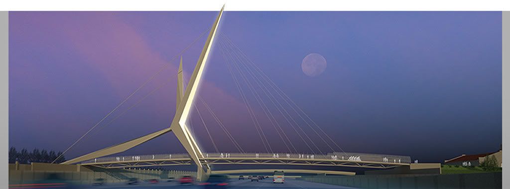
Hey Great news – The City unveiled their choice for the New I-40 Pedestrian Bridge – Of the 4-5 finalists, they chose a design by Hans Butzer, inspired by Oklahoma’s own scissor tail. I’m glad they chose someone from the home team!
As far as I’ve seen, the credit goes to “mturner” for breaking this story, and hats off to him or her! Where was the Oklahoman, or the Journal Record, etc., on Friday, September 5 — out of town somewhere? I mean, if this proposal comes to be completed as planned, we’re looking at something which could well be a “stamp” for this city close to if not the same as St. Louis’ arch is for that city, in my opinion.
Anyway, “mturner’s” post caught my fancy and I continued reading the thread — at the time, I was unaware of what his comment meant. There, after passing by a rather mundane image in the thread of a “pedestrian crossing” (which, it seems, didn’t directly relate to this project at all), I eventually came across the image which is the lead-in to this post — and that striking image put my immediate interest on a much higher level than before the time that I saw it.
Although no mainstream media contained any reports about this project until September 9 (only God knows or could possibly understand why not), the City of Oklahoma City’s September 4, 2008, press release reads:
A model of the proposed I-40 pedestrian bridge will be unveiled and the winning design firm announced at 4 p.m., Friday September 5 outside the Council Chamber on the third floor of City Hall.
More than 16 design firms responded to the City’s request for proposals and design competition for a pedestrian bridge over the realigned I-40. Four firms were selected to compete, each receiving $10,000 to build a model of the bridge design and prepare a presentation.
A committee of qualified jurors from the community at large, downtown central business district, Core to Shore area, City of Oklahoma City, and State of Oklahoma reviewed the four models and selected the winning design.
On Tuesday [ed note: presumably September 9, 2008], the City Council will vote to authorize staff to negotiate a contract with the winning firm for the bridge design. Actual construction of the bridge should begin in March 2010 and will be overseen by the Oklahoma Department of Transportation as part of the I-40 Realignment Project. [Emphasis added]
The winning entry was submitted by the firm headed by Oklahoma Citian Hans E. Butzer, Butzer Design Partnership. Butzer is an associate professor of architecture at the University of Oklahoma, he also designed the Oklahoma City National Memorial and Museum and the Route 66 Interpretative Center in Chandler. His vita at the OU link, above, shows many other of his accomplishments. Others are involved, too, and I’ll add their names as they become available from authoritative sources.
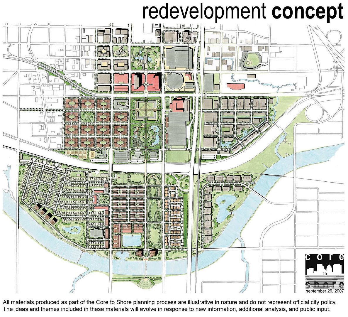
ORIGINS. The I-40 Pedestrian Bridge is one of many projects spinning out of Oklahoma City’s “Core To Shore” city planning. By way of background, a 12-month review process by the plan’s steering committee completed its work in December 2007. See this December 13, 2007, Journal Record article for a little more background. By late 2007 or early 2008 (I’ve not located an exact date), the City’s huge “Final Plan,” a 118-page PDF file describing the concepts, plans and aspirations became available on-line at this page of the City’s website. Page 1 shows a concept of what the area bounded by the “core” (current downtown) to the “shore” (Oklahoma River with a southern pedestrian crossing into Wiley Post Park) might look like:
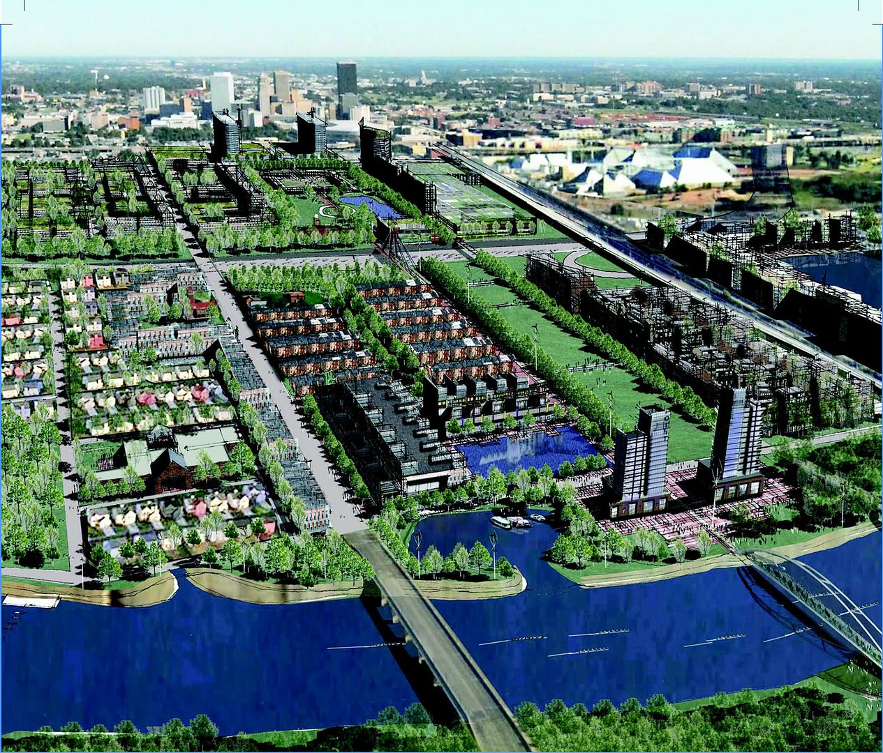
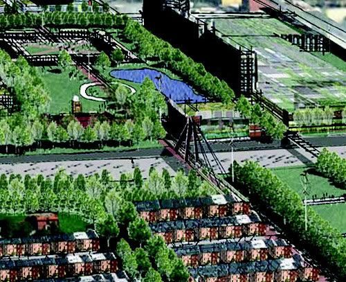
A center-top crop of the above shows the I-40 Pedestrian Bridge Location
To read more from the City’s Core To Shore web pages, go here. Also, see this nice May 14, 2008, USA Today article.
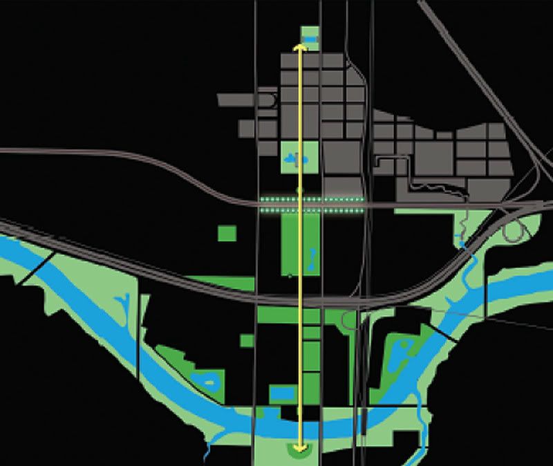
The I-40 pedestrian bridge is part of a larger concept — the “pedestrian spine” referenced in the Core To Shore documents which runs along where Harvey would be from the south end of Myriad Gardens to about a mile south to Wiley Post Park on the south side of the Oklahoma River. Page 17 of a 55-page presentation made to the City Council in late 2007 shows that “spine” by the yellow vertical line in the middle of the Core To Shore area:
In late 2007 or early 2008 (I’ve not determined the date), the City solicited competitive designs for this project, indicating that submissions needed to be made by March 10, 2008, and a “Background” document was published which contained the following images:
Click the image for a larger view
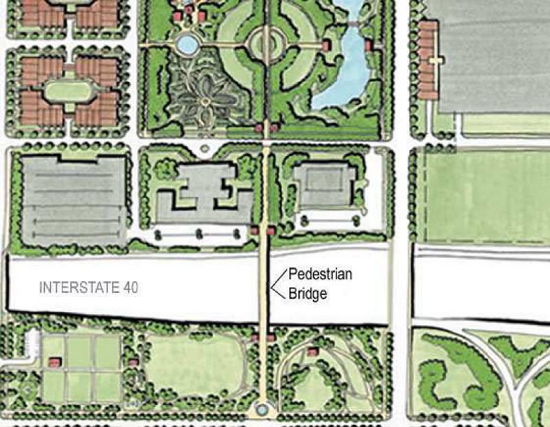
Some facts gleaned from that document are:
- Estimated Cost: $3,300,000
- Dimensions & Location: 30 feet wide and 440 feet long over the new, semi-depressed section of 10-lane interstate highway and the BN&SF Railroad, on the south edge of downtown Oklahoma City
- Function: Provide access and connection for pedestrians and bicyclists between a new large park and proposed new convention center and hotel north of I-40 with a smaller, promenade park, one block in width, which continues south to the Oklahoma River
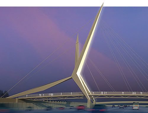
Page 70 of the 118-page PDF file, mentioned earlier, said that the bridge should be a city “landmark,” and showed this as a possibility:

THE WINNER! As noted above, Oklahoma Citian Hans E. Butzer’s group won the competition.
On edit: Although no Oklahoman news stories were published as of 9/8/2008, its website has added a nice interview with architects Hans Butzer (unless his OU website is wrong, it’s Hans, not Hanz, as shown in the interview) and Stan Carroll:
And, on September 9, a nice article by Steve Lackmeyer hit the press.
Architectural Renderings. From that organization’s website, the following images are presented of what motorists and others will see around the new I-40 and what would be Harvey Avenue:
A crop from the above (larger image not available)
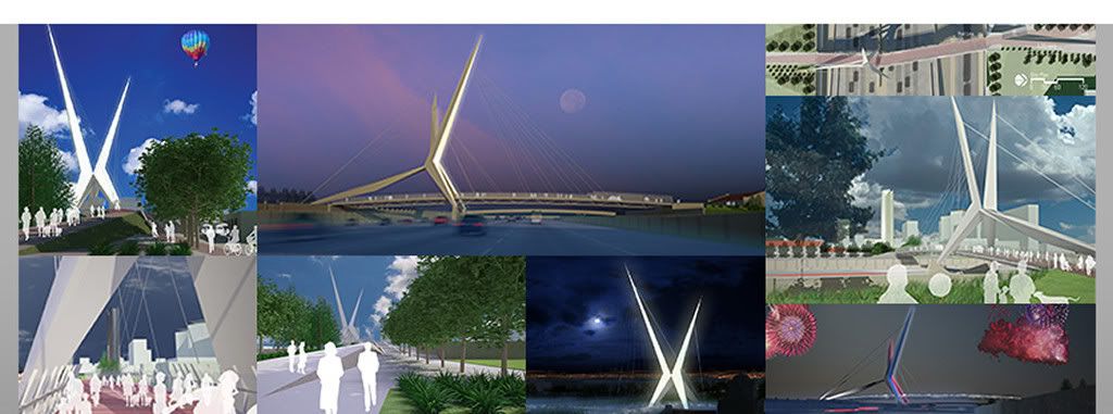

The text at the right side of the above picture reads:
Like Oklahoma City’s skyline, SkyDance Bridge pierces the expanding blue sky against horizons of waving wheat. Much of this capitol city and state’s history is defined by the sweeping Oklahoma wind. From Images of the tall grass prairie to the achievements of Wiley Post, Braniff Airlines and Tinker Air Force Base, to the expanding wind farms in the west, sculpted blades rise up to slice the wind. Graceful boat sails glide across our countless lakes and waterways. The flight of the Scissor-tailed Flycatcher perhaps best evokes the shaping forces of our wind. This State Bird’s “skydance” of spring is a v-shaped flight drawn against the sky. Its wings and tail feathers angled by nature cut like blades through the wind. So, it is from these that SkyDance Bridge takes foothold and projects its iconic form onto the Oklahoma City skyline.
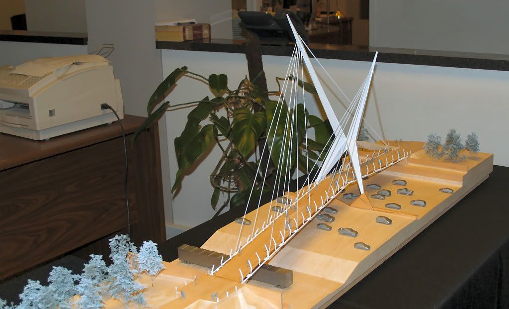
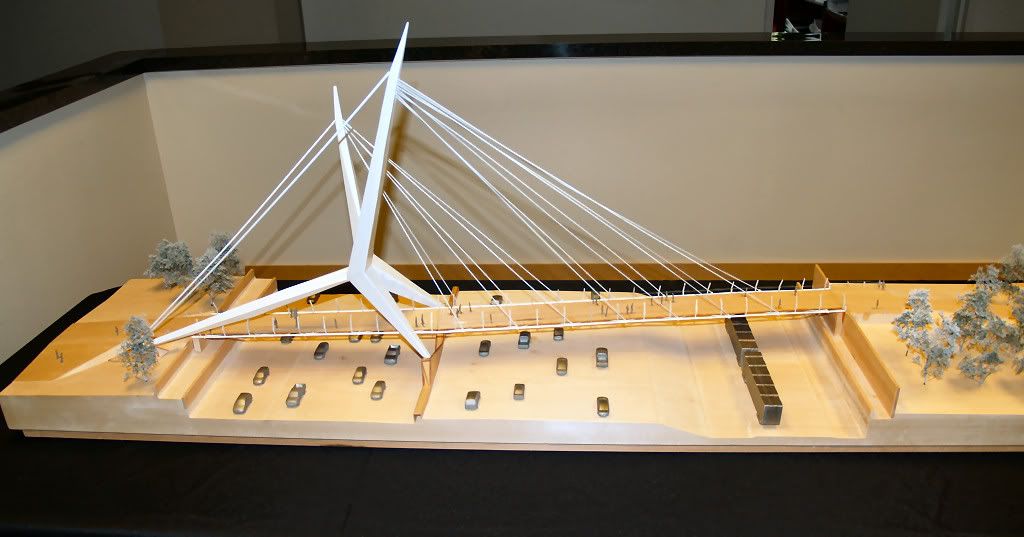
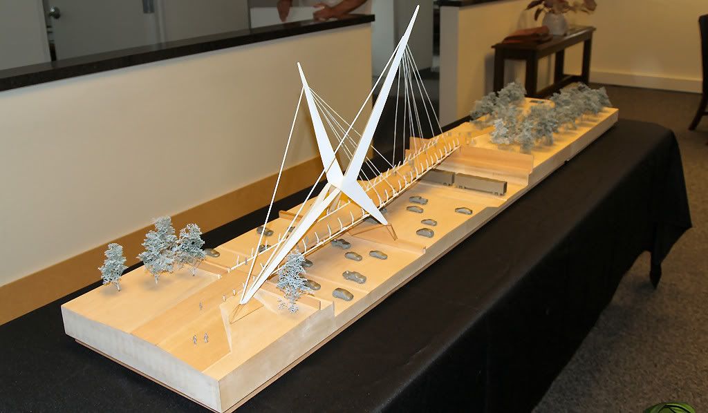
The Model. I trotted down to City Hall this afternoon (9/8/2008) and found the SkyDance model in the City Council’s offices and was kindly allowed to take some pics. Here they are, going around the model in clockwise rotation, starting at about 6:00 o’clock — click any photo for a larger view:
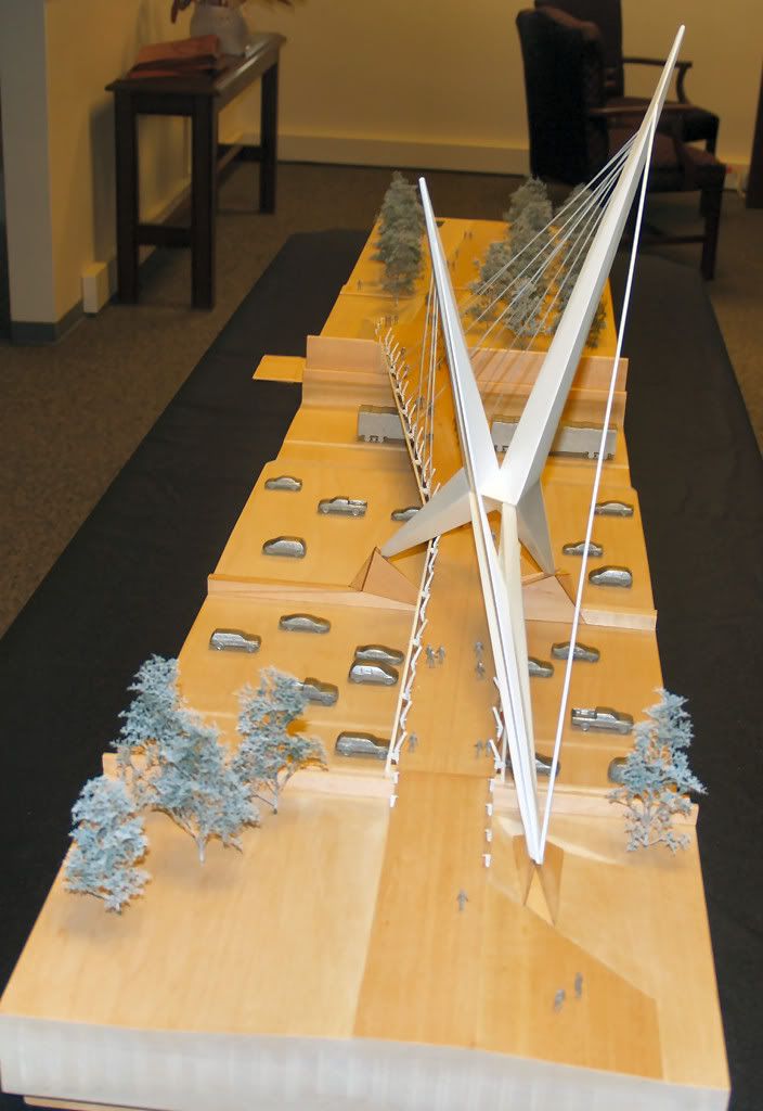
Southwest to Northeast
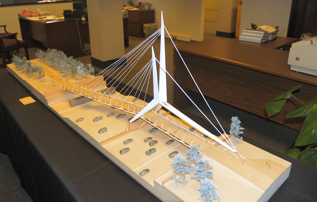
West to East

Northwest to Southeast
Northeast to Southwest

East to West
Southeast to Northwest
If the completed project looks like the drawings and the model, motorists’ jaws should drop as they drive under this bridge as they travel east and west on the new I-40, especially at night — and not just theirs, but ours, as well.
How Tall Is It? I’ve seen nothing published yet that says. But, Spartan, over at OkMet.org, wants to know (and, of course, so do I)! I’ve constructed a “model” using the west to east view by inserting it into a spreadsheet and made each horizontal unit (cell) 0.2″ in height and width. The City’s Background document said that the bridge length was to be 440 feet. So, guessing at the points at which the bridge “proper” begins and ends, below, I came up with the following as a guesstimate:
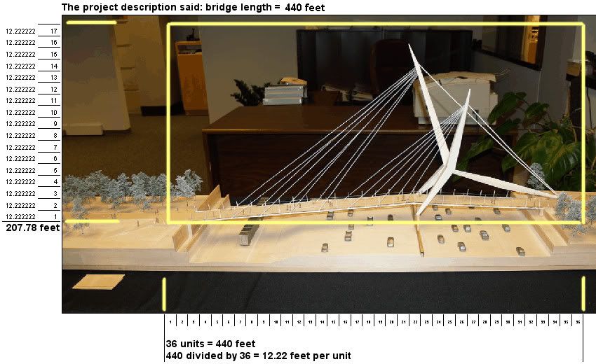
I take it as given that the model is to scale. Since the model in the photograph is tilting toward the camera, it will appear to be lower in height than if a horizontally level photo had been taken. So, if I have reasonably placed the beginning and ending points of the 440′ bridge, the approximate height would appear to be 207.78 feet, ± about 10 feet, I’d suppose. What’s your guess?
NEW FUNDING CONCERNS. On September 7, 2008, News9.com reported that problems with the Federal Highway Trust Fund are causing concern about the federal government’s substantial funding of projects like the I-40 Relocation:
Ninety percent of Oklahoma highway and bridge projects are paid for using federal funds. Even the Interstate 40 Crosstown relocation project could be put on the back burner if state officials don’t find a solution or more money soon.
“I know that at least a dozen people at the department have lost sleep over this, literally,” ODOT spokesperson Terri Angier said. Angier isn’t sleeping much these days either. “It’s fairly devastating news for Oklahoma,” Angier said.
Late on Friday, a notice came in warning the Federal Highway Trust Fund will dry up at the end of this month. The federal government blames high gas prices, less driving and lower gasoline tax revenue for a $200 million shortfall.
Since federal funding pays for almost all bridge and highway projects in Oklahoma, the state could now be stuck with more of the bill, which could lead to more delays. “Basically it simply means you go enter into contract and send us a bill and we’ll see how much we can pay,” Angier said.
Normally, the federal government reimburses ODOT for construction projects on a daily basis, but this shortfall puts the repayments on a weekly basis. “Even at that, it’s only a portion of the reimbursements,” Angier said.
Many are wondering if the shortfalls will make ODOT pull the plug on projects like the long anticipated I-40 Crosstown Bridge or the proposed I-40 Pedestrian Bridge.
The Oklahoman carried a similar story on September 9. My guess is that the problem will be short-lived, but the days and months ahead may well be telling.
This page will be expanded and updated as further developments occur.