
For Part 1, Oklahoma City’s Population History, click here
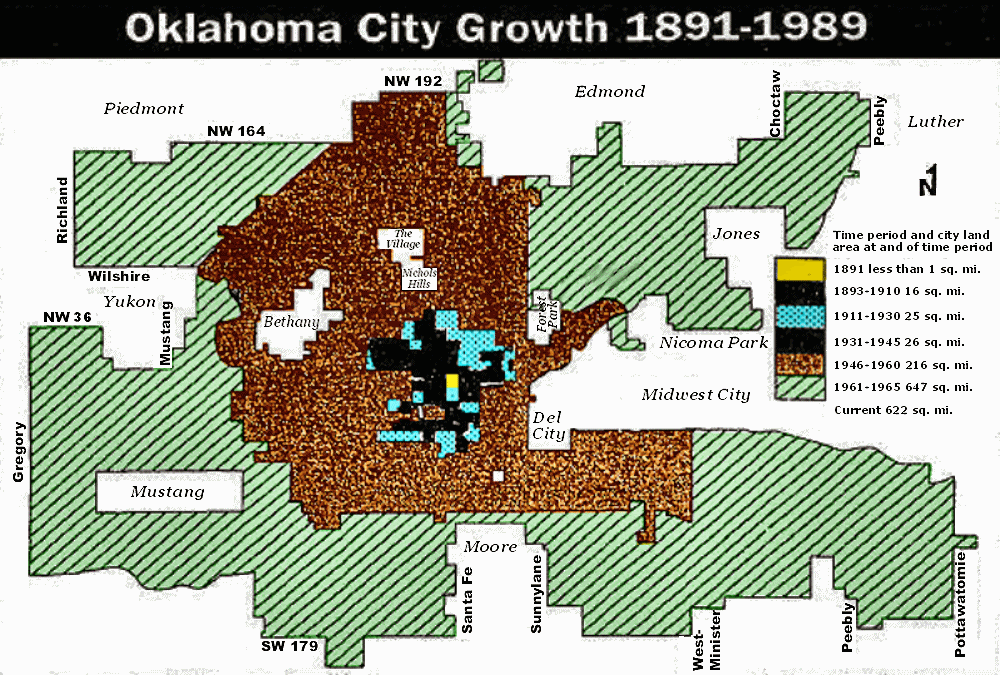
SPATIAL AREA OF OKLAHOMA CITY. This section traces Oklahoma City’s change of spatial area from its beginnings until the present day and it makes a stab at answering the question, “How did Oklahoma City ever get this sprawly-big? Roughly, that’s about 39 miles east-west and 28 miles north-south, with lots of pockets which are not part of Oklahoma City proper. Another well-documented piece on this topic is Jack Money’s article at www.okchistory.com.
The Early — 1957-58 Years. Notwithstanding that Oklahoma City was “born grown” with 10,000 inhabitants on the nightfall of the Land Run of April 22, 1989, lots of those folk didn’t stick it out. By the 1890 census, Oklahoma City’s population was 4,151. According to an excellent 1999 article by Jack Money & Steve Lackmeyer (here, it is broken into two parts: part a, and part b), Oklahoma City’s 1891 area was less than one square mile!
NOTE: In many instances below, rather than including actual Oklahoman articles in the display here, I’ve linked to them so that you can read such articles if you want (as I’ve done, above). They will open in a separate window or tab.
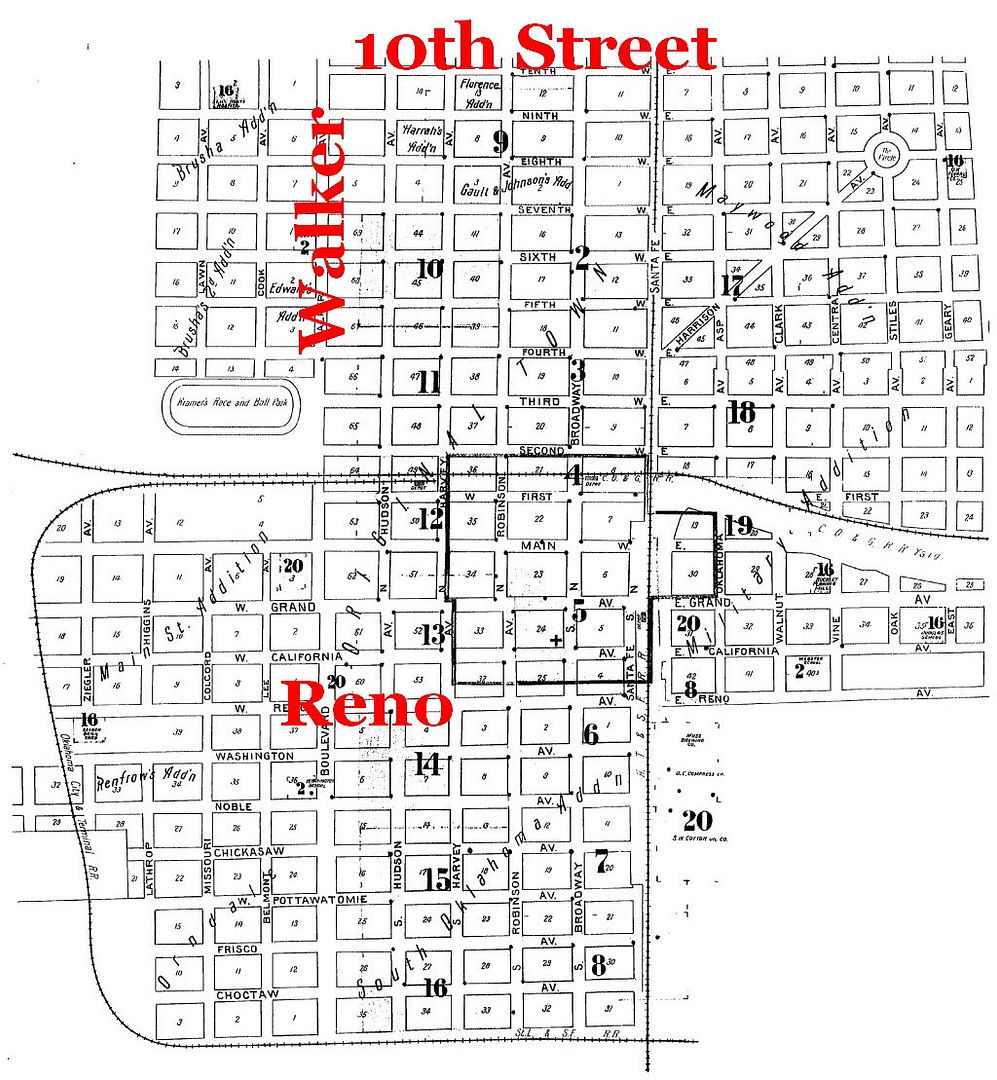
Things picked up after the 1890 census and the same article reports that by 1910, Oklahoma City embraced 16 square miles (population 64,205). Before that, Oklahoma City’s corporate area looked like this in 1901 (Sanborn Map Company, notations supplied):
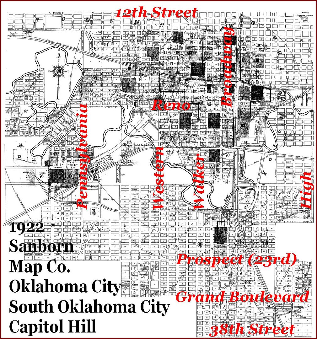
By 1922, Oklahoma City’s population was about 100,000 and the area of Oklahoma City, South Oklahoma City, and Capitol Hill is shown in the marked-up version of a map by the Sanborn Map Company, below, the company making maps for the insurance trade:
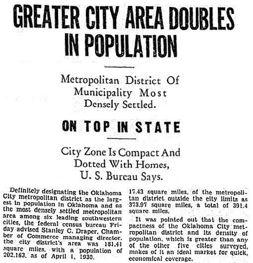
The city was 30.35 square miles in 1930 (population 185,390) but had somehow dropped by the early-to-mid 1940s: a January 3, 1943, article reports the city’s square mileage to be 25.3, and a 1948 article show it to be 28.6 prior to a pending annexation (see the later article below). So, even though Oklahoma City’s population was 204,424 in 1940’s census, with its slightly decreasing area, Oklahoma City’s population increasingly became more dense. An Oklahoman editorial commented upon the 1930 census data (wherein Oklahoma City overtook Tulsa as the state’s largest metropolitan as well as city proper population) and the virtues of “compactness” and “density” were extolled. A snippet from the headline is shown below …
or here for a single file containing the entire article.
A May 4, 1949, Oklahoman article shows the area proposed to be added to Oklahoma City at that time — 19.2 square miles which would have added 22,398 to Oklahoma City’s population — click on the link or on the graphic below for the full article:
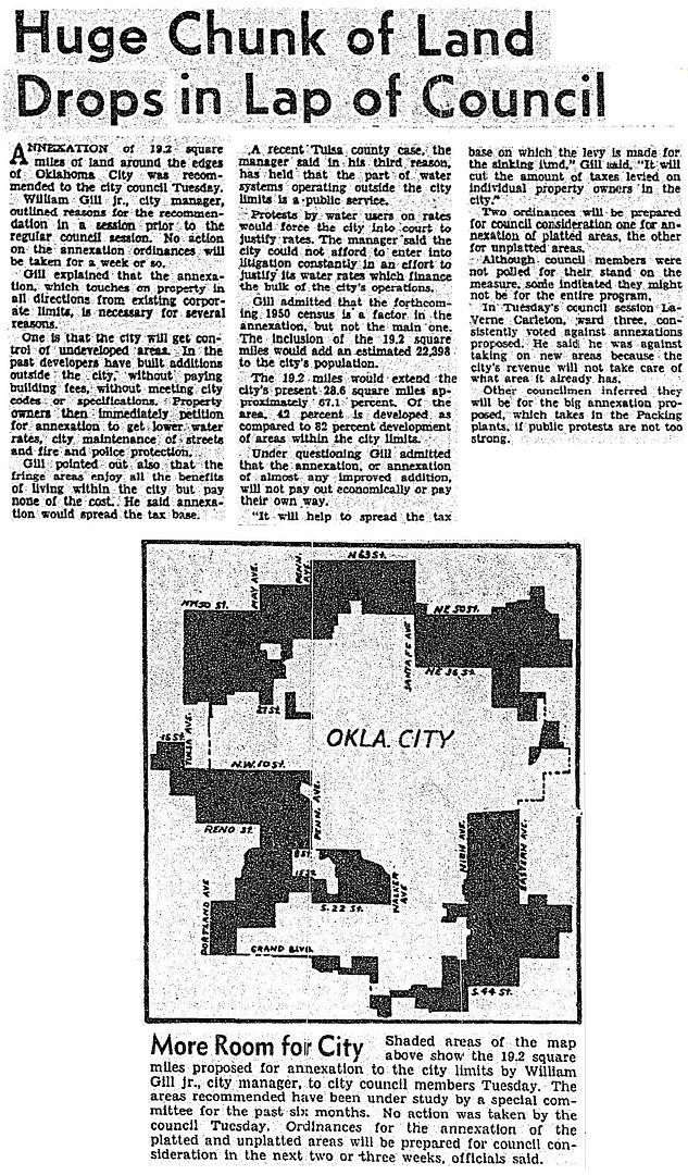
However, objections at four public meetings were so strenuous that the project was either dropped or deferred. Less ambitious annexation proposals by the Planning Commission were considered from 1950 through 1954-55 and Oklahoman articles reflect no enthusiasm by the City Council to rubber stamp such requests. Meanwhile, Midwest City, Del City, and Warr Acres proceeded apace, the latter beating Oklahoma City’s intended annexation of a small area to the punch in 1952 while Oklahoma City dawdled in its own plan to annex the same area. Even so, a
Hence, while a review of Oklahoman articles through the mid-1950s does reflect on-going annexation (with a thus-far unexplained shrinkage between 1930 and 1943), actually approved annexation was mostly associated with “close-in” annexation of typically small tracts which were proximate to the city’s population center and not out in the boonies somewhere and was not done without objection. In the early-to-mid 1950s, square mile increases were not shocking: 1953 — 56; May 1956 — 71; September 1956 — 76; July 1958 — 80. A September 19, 1956,Oklahoman article said that Oklahoma City had started a “major annexation program” at some unidentified time earlier and although the city’s size was comparatively larger it was not behemothly so. And, the expansions were typically what one would expect — inclusion of areas that the city had naturally grown into. The city’s failed attempt to annex the Forest Park area before it became a town — see this May 23, 1956, article for the annexation and this October 30, 1957, article reporting Forest Park’s court success in defeating that annexation — did reflect a certain aggressiveness on the part of Oklahoma City, as did the city’s expansion eastward toward Tinker Air Force Base (then Tinker Field) in September 1956.
1958 through 1986. At some point in 1958, apparently December, things changed. In an October 9, 1959, Oklahoman article by Jim Reid, the headline reads, “City Spells Out Annexing Policy.” In the article, Reid said that the “current” annexation program started in December 1958. Although no article in December 1958 (or other proximate date) was located which said the same thing, the unsupported assertion by Mr. Reid does match with a conference called by Mayor Street in December 1958 conference on “Oklahoma City’s proposed metropolitan planning.” This December 11, 1958, article describes the event which was sponsored by the Oklahoma City Chamber of Commerce. Street sent invitations to city council members, mayors of Oklahoma county’s cities and county commissioners to hear consultants from Evanston, Illinois, as they discussed metropolitan planning and urban renewal. And, thereafter, it is quite evident that the city’s expansion mode changed from one akin to osmosis to one which projected population expectations in the future so that the city would have more control and management over the growth of those areas. In this time, Oklahoma City leaders were expecting a population growth to a million or so people in a fairly short span of time.
WHY THE ANNEXATION DRIVE? Much of the assimilation during this period was basically sparsely inhabited unincorporated territory. Why assimilate essentially agrarian land into the more densely populated city proper? Oklahoma City was planning for and expecting rather dramatic growth, especially to the north, possibly up to a million inhabitants by a couple of decades (even though that didn’t happen, and still hasn’t). Oklahoma City wanted to avoid a situation where the central city was carrying a larger share of the cost load than those on the periphery even they they shared in the benefits, plus Oklahoma City wanted control over that expanding development. Oklahoma City wanted more control over its destiny than a more passive annexation mode would allow.
Additionally, such planning projections did not exist in a vacuum — Oklahoma City was not “alone” in the list of regional municipalities wanting their day in the sun. Oklahoma City’s needs might well come head to head with other cities’ planning needs associated with population expansion, e.g., utilities, water, and transportation. Nationally, it was observed that core cities like Pittsburgh who carry the financial weight for its suburbs have an overly large share of the financial load while having no or little control over their suburban kin. This notion, it seems, is at least a part of Oklahoma City’s agenda beginning in 1958.
What would Oklahoma City need to do to insure that other metro cities such as Edmond, Norman, Shawnee, Guthrie, Moore, Midwest City, did not preempt Oklahoma City by beating Oklahoma City to the punch?
The answer was simple — beat them to the punch by preemptive first strikes and lots of ’em! A December 17, 1958, article reported that Midwest City had just amended its city charter to prevent its annexation without Midwest City’s consent, Bethany having done the same earlier in the year.
And so it was that from late 1958 through August 1986 that Oklahoma City became seriously aggressive in its annexation of adjoining areas, not just a little, but a lot.
As a side-note, it is worth mentioning here that in 1955 or so Oklahoma City formally or informally adopted a slogan, “600,000 in 1960.” The number was related to the metropolitan area and not the city proper. Regardless, Oklahoma City did appear to be on a population quest. One means of accomplishing that quest was annexation, and Oklahoma City pursued that means with a gusto.
By July 1958 Oklahoma City’s square mileage was 80 but it would double less than a year later. A January 7, 1959, Oklahoman article gave a preview — areas around the then proposed Cowboy Hall of Fame and around Tinker south toward the then proposed reservoir owned by the city but located in Cleveland County (Lake Stanley Draper), that annexation being completed later in the month.
Oklahoma City’s aggressive annexation had become a hot topic, enough to warrant a February 14, 1959, Oklahoman editorial which favored it and a mayoral candidate whose campaign ad was in opposition.
An April 2, 1959, Oklahoman graphic showed what was then on the annexation table:

In May, it was action time. Click the links below to read the articles:
- May 6, 1959: Size of city reaches 116 square miles
- May 13, 1959: Another 12 square miles
- May 20, 1959: Another 1,400 acres
- May 22, 1959: More added bring the city’s square miles up to 160 and down to the Cleveland County line, the first instance that Oklahoma City’s boundary abutted another county’s border
- May 29, 1959: An item is on the Council’s agenda which would extend Oklahoma City INTO Cleveland County
By the end of May 1959, Oklahoma City had doubled its July 1958 total. The pre-May 1959 forays were relatively modest, comparatively speaking, but if the alarm hadn’t already been sounded for Oklahoma City’s neighbors, by the end of May 1959 it certainly was. This one was big and Oklahoma City was and was increasingly seen as …
A June 14, 1959, Oklahoman article (without author attribution) reported on the opinions of city planners. The lead-in begins, “Here are the ABC’s of Oklahoma City’s annexation as explained Saturday by some of the city’s top planners. Experts promise that Oklahoma City’s chances are fine for becoming a city of one million in the next 15 to 20 years.”
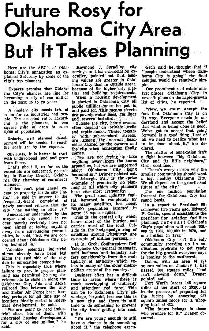
In the article, Stanley Draper, Chamber of Commerce manager, said, “We are not trying to take anything away from the towns around us, but we are concerned about Oklahoma City being hemmed in.” Pittsburgh, Pennsylvania, was held up as an example of how things can be if not city planning does not properly occur. The article says,
The great steel industry capital, hemmed in completely by its many satellites, has about 750,000 population jammed in some 55 square miles. ¶ This is the central city which bears most of the burden and carries most of the load. Outside in the hodge-podge ring of satellites around Pittsburgh are a couple of million persons.
Dallas and Ft. Worth were held up as examples of cities which Oklahoma City would do well to emulate.
Good enough and forget the slowdown! The stalled expansion into Cleveland County proceeded, as did more.
- A July 1, 1959, Oklahoman article reported that the council had just added some additional turf there, upping the city’s total square mileage to 217.5.
- A July 29 look at the city showed that the north/south city mileage was 25 miles
- August 20: Bill Burkes, city planning statistician, complained that he was having trouble finding a place for the city’s map because the 14-foot ceiling wasn’t high enough
- August 26, 1959: Another 28.7 miles added. The article noted that a record series of 24 annexation ordinances had swelled the city’s area to 265.1 square miles.
- January 1, 1960: Another 21.46 square miles along the “big bend” of the North Canadian River, north and east of Spencer, one-half mile from Choctaw and Jones
- March 2,1960: 26 square miles in the areas shown below … click the link or the map to read the full article
- March 30, 1960: 9.75 square miles in Cleveland County near Moore; suit was promised by property owners saying they had already petitioned Moore to be annexed by that city and it was filed by the April 6, 1960, article which reported it (I didn’t locate the outcome but Oklahoma City won far more disputes than it lost)
- August 17, 1960: Another 3,440 acres (5.38 square miles) in Cleveland County bringing Oklahoma City’s size to 370 square miles
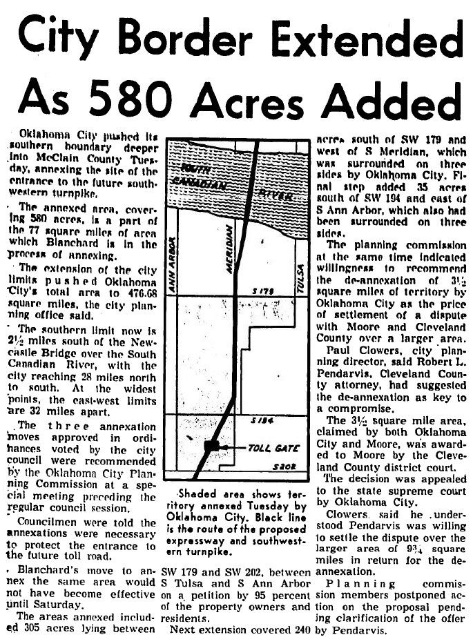
- August 20, 1960:Another 22.5 square miles bring the city’s total to 392, mostly in Cleveland County but some in Canadian and McClain Counties; the 5½ square miles picked up in McClain County along the US 62 corridor where I-44 would come to be built, south of the Canadian River near Newcastle (this would later be agreeably de-annexed by the city, explained below) expanded Oklahoma City’s presence to four counties: Oklahoma, Cleveland, Canadian, and McClain
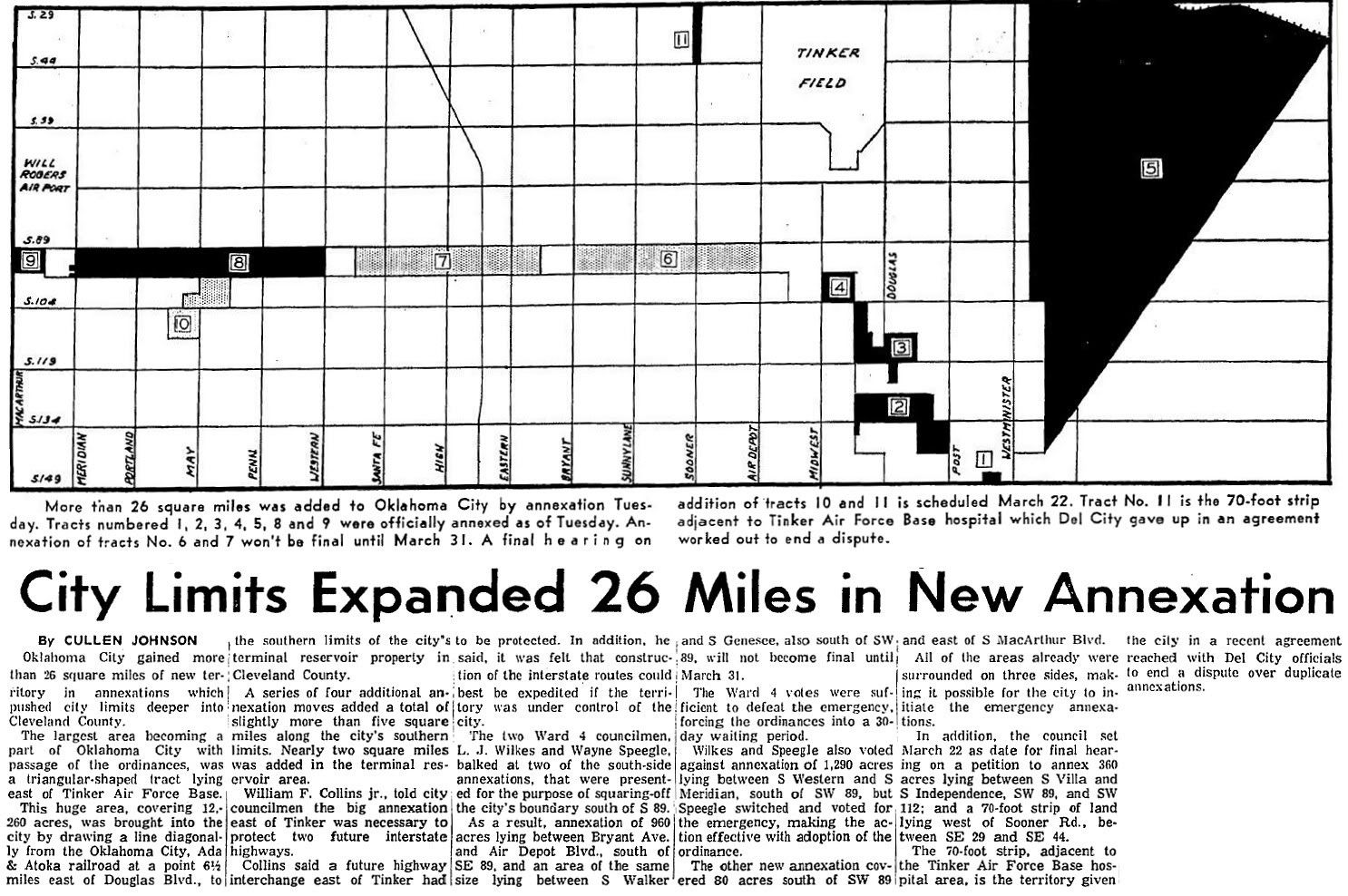
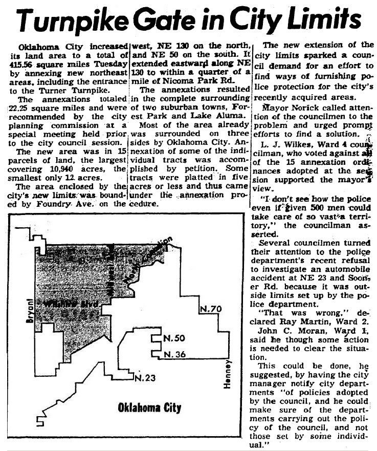
- September 7, 1960: 22.25 square miles in north central/eastern Oklahoma County, surrounding Forest Park and Lake Aluma and including the I-44 turnpike gate, bringing the total to 415.56 square miles; Council member L.J. Wilkes and Mayor Jim Norick expressed frustration about the city’s inability to provide adequate police protection, but Council member John Moran opined that the police would be enabled by the annexation to provide protection they could not earlier give; click the link or the map below for the full article
- November 1, 1961: 42 square miles were added in southeast Oklahoma County extending to the Oklahoma/Pottawatomie County line, bring the city total square miles to 475.55
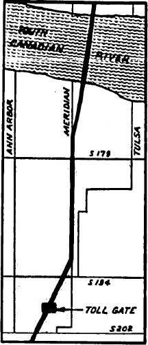
- November 29, 1961: Another little piece of McClain County around the I-44 toll gate 2½ miles south of the Canadian River (which toll gate no longer exists) was added, bringing the city’s total square miles to 476.68; click the link or the map below for the full article
- March 21, 1962: 55 square miles were added in eastern Canadian County between NW 36th and SW 89th, including Cimarron Field used during World War II to train Army Air Force pilots; total square miles became 538.268 and the east-west boundary distance became 39 miles
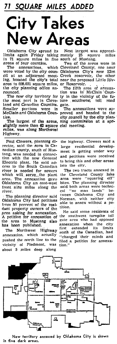
- April 7, 1962: 71 square miles in the same 4 counties mentioned previously bringing the city’s total to 608.031 square miles; click the link or the map below for the full article
- April 25, 1962: 320 acres (½ square mile) were added — although relatively insignificant in size, this single acquisition represents Oklahoma City’s sole entry into Pottawatomie County to date and it still stands, nubbin that it is. But, why stick a finger into Pottawatomie County, one might ask? Read the article and see the reasons given there. Reasons given don’t include the likelihood that Pottawatomie County would be included in the Oklahoma City Standard Metropolitan Statistical Area and that strikes me as a more likely cause. Ordinarily, as was explained in this October 10, 1963, Oklahoman article, it was more or less automatic that both Pottawatomie and McClain Counties would be included in Oklahoma City’s SMSA since a part of the city was within both of those counties. Enter Representative Tom Steed, Shawnee, and member of the House of Representative budget appropriations subcommittee, and violently opposed to Pottawatomie County’s inclusion in Oklahoma City’s SMSA. Using his influence, the census people backed off and Steed won the day.
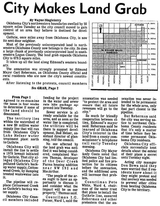
- August 13, 1986: 58 square miles in northwest Oklahoma County and a piece in Logan County next to Guthrie, bringing the city’s total to 679.5 square miles, or, rounding up, to Oklahoma City’s apex at 680 square miles; much if not all of the the Logan County property would later be agreeably de-annexed; click the link or the map below for the full article
That pretty much wraps up the Oklahoma City’s the story on Oklahoma City’s pinnacle of growth although a few smaller annexations are omitted.
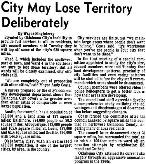
STEPPING BACK. Voluntary shrinkage began to occur in 1986 during Mayor Andy Coats’ tenure although it was earlier considered in Mayor Patience Latting’s time. See this September 24, 1986 Oklahoman article which considers the opposite side of the annexation coin and October 6, 1986, article which does the same. A lengthy article appeared on the same topic in the August 3, 1987, Oklahoman, so long that I’ve broken it into two parts: Part A and Part B.
As for what actually was de-annexed, it came in pieces. As best as I’ve been able to determine, here’s what happened with Logan and McClain Counties.
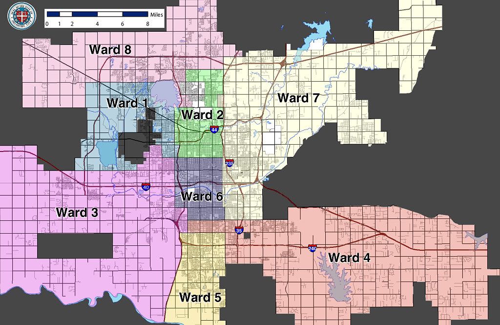
Part of the land acquired in Logan County and northern Oklahoma County was let go rather quickly after it was acquired, as mentioned in this September 24, 1986, Oklahoman article. Ironically, after de-annexation, some who had been affected petitioned Oklahoma City to “get back in,” but a November 13, 1987, article reports that their petition was denied. Although part of the Logan County area was de-annexed, a petition that much of the remainder was denied. See this this October 16, 1986, article for a report on the request, and this November 11, 1986, article for city council’s denial. At this writing, I’m uncertain as to whether any portion of Oklahoma City lies in Logan County, but I don’t think that it does — Waterloo Road is the Oklahoma/Logan county line, and Oklahoma City’s present Ward Map shows the northern city boundary to be about half-a-mile north of NW 192nd which is 4 miles south of Waterloo Road. I’ll update this later if and when I find out with certainty, but it does not appear that Oklahoma City presently lies in Logan County.
McClain County property was released in stages: 1st, on petition by McClain County citians, in 1977 a 9 square mile part was let go. Later, in 1992, the remnant 1.6 square miles were released on petition, as well. This September 9, 1992, article reports on the petition, and this September 11 article reports that some did not want to leave Oklahoma City and become a part of Newcastle. This December 9, 1992, article reports that the council approved of the de-annexation request. Probably, there are a few others that escaped my attention as to how the city’s remaining 622 square miles has remained stable for quite some time.
The 320 acres (½ square mile) in Pottawatomie County remains part of Oklahoma City as this is written.
The chart below shows the dramatic story:
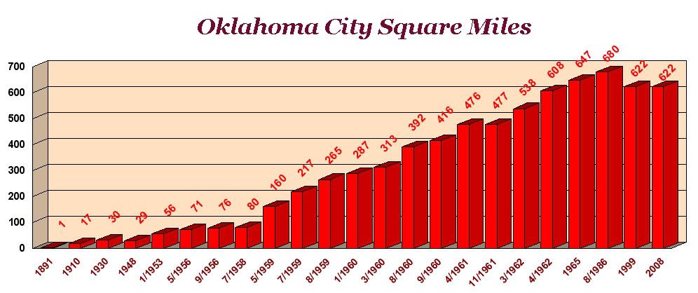
So, Doug Dawg spiffed it up a bit and made it more better!
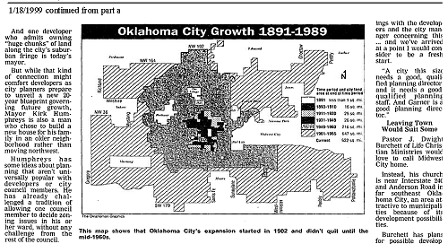
Another nice but less complete retrospective article, this one by Brian Brus, appeared in this April 18, 1999, article.
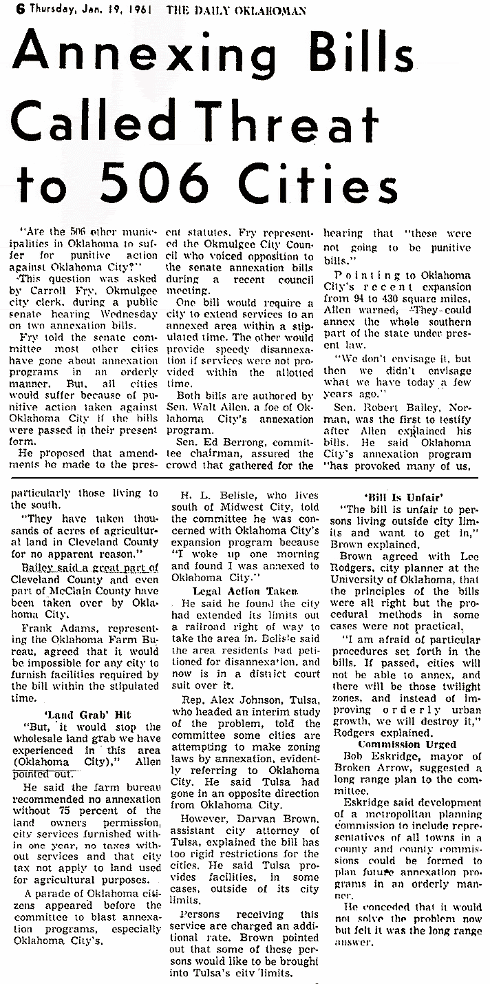
 RESISTANCE WAS FUTILE. Efforts were made during Oklahoma City’s expansion period to stop it. Almost always, those attempts failed. This September 16, 1959, article describes Chickasha State Senator Walt Allen’s intention to slow it down. The article says that he and another senator had said that, “many cities within a 50-mile radius of Oklahoma City are fearful ‘they will be gobbled up’ unless the present law is changed.” A September 10, 1960, Oklahoman article reported that the executive committee of the legislative council adopted a proposal of Norman’s State Senator Robert Bailey to study a revision of annexation and dis-annexation laws. Meeting in Tulsa, the article reports that Bailey told the legislative council, “Now they are three miles out on the turnpike and are coming this way,” an allusion that Tulsans, too, should be worried. In 1961, legislation was introduced which would limit Oklahoma City’s expansion. But, the legislation was ultimately seen as unduly restricting other cities in their own circumstances and it was not passed.
It should also be mentioned that Oklahoma City was not the only land-grabber in the metro. Whether acting defensively or for their own future needs, cities like Edmond, but particularly Norman, did much the same. For example, see these articles concerning Norman’s annexation: July 16, 1960, and July 27, 1960.
Anyway, Oklahoma City rarely suffered defeats in its 24-year long drive to annex the territory which would become a part of the home of its expected 1,000,000+ inhabitants. As of this writing, the Bureau of the Census estimates Oklahoma City’s 2006 population at 537,734. But, maybe the hope, “If you build it, they will come,” has just not had time to fully materialize!
Maybe next year!